


Osaka Metro Group 案内アプリ app for iPhone and iPad
Developer: Osaka Metro
First release : 15 Mar 2020
App size: 84.51 Mb
■ Features
This is a railroad companys application which is convenient and useful in business settings, commuting to and from work or school and sightseeing and provides information about stations, bus stops and surrounding facilities of Osaka Metro Group.
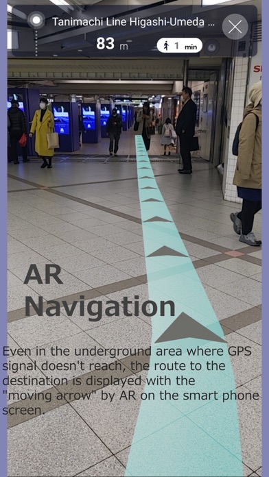
This app provides seamless guide using AR from the board near a ticket gate to station exits/entries, bus terminals or major commercial facilities so that the user can go to the destination without getting lost in the complicated underground area.
-Guide to 741 spots around the stations
-AR navigation of 496 routes (provided in sequence)
-Timetable widget available, for the first time as a railroad application
-Distribution of accurate service information
■ Main functions (free of charge)
AR Navigation
Even in the underground area where GPS signal doesnt reach, the route to the destination is displayed with the "moving arrow" by AR on the smart phone screen. The guide of the route around Umeda Station*1, where there is a complicated underground area and various transits occur, has been enhanced so that customers using Osaka Metro Group can go to their destinations smoothly without getting lost. (For the areas where AR navigation is not available, guide using 2D maps is provided.)
*1 Including all exits/entries of Umeda Station, Higashi-Umeda Station, Nishi-Umeda Station, Namba Station, Dome-Mae Chiyozaki Station and Taisho Station, transfer routes on Osaka Metro or to other railways, Osaka Metro Group underground facilities, and commercial facilities
Service information
You can register stations and routes that you frequently use. If any trouble of train service such as delay occurs, the notification is displayed on the TOP screen of your smart phone. By tapping the notification, you can move to our website and see the detail.
Route map
The Osaka Metro route map is displayed. By selecting a station on the route map, you can search for the guide of the route. Using the current location button, you can also search for the nearest station.
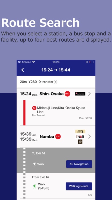
Guide of route
When you select a station*2, a bus stop*2 and a facility, up to four best routes are displayed. After the route search, the route guide display using the AR navigation function and the outdoor map is also available.
*2 This service provides the information only for "Osaka Metro Lines", "Kita-Osaka Kyuko Railway" and "Osaka Metro/City Bus".
Stations/Lines
The map*3 of each station of Osaka Metro, the underground shopping center and surrounding spots of each station are displayed.
*3 Only in Japanese
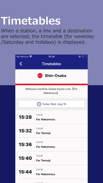
Timetable
When a station, a line and a destination are selected, the timetable (for weekday/Saturday and holidays) is displayed. If you register stations and lines that you frequently use, you can check the timetable by the widget function without opening the application.
Display for foreign tourists visiting Japan/foreign residents in Japan
The language setting on the user terminal allows automatic setting of display language. When you select "Travel" for the purpose of use, the service links to our website for foreigners visiting Japan to provide you with sightseeing information.
Registration of My Station
You can register up to six stations that you frequently use. The timetables and weather of the registered stations can be checked on the TOP screen, and the registered stations can be easily selected in searching a route, timetable, etc.
Drawer menu
This allows you to move from any screen to each function and setting of the application.
[Note]
-Some contents require data usage. You are to pay the packet data usage fee for data acquisition.
-Operation on a tablet terminal is not guaranteed.
-Depending on the memory availability or signal condition of your terminal, the application may not operate normally. In that case, after checking the status of your terminal, try again.
-Since this application uses the current location function, the location information of your terminal is automatically acquired.